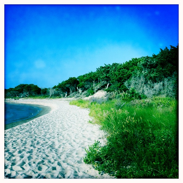
The Beach at Springer's Point
You can find this gorgeous beach at Springer's Point on Ocracoke Island, an island in the chain of land strips known as the Outer Banks that lie off the coast of North & South Carolina.
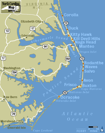
The Outer Banks
If you examine the eastern most strips of land on the map above, you can see that the Outer Banks are, essentially, giant sand bars. They protect the mainland coast from storms and hurricanes and create a safe haven for ships that wish to rest in the Pamlico or Albemarle Sound. A century ago, these islands were key ports for trade. As plane transport became increasingly popular the islands' port functionality became decreasingly important, and ironically, plane popularity took hold in part because of important research gathered on the Outer Banks by the Wright brothers. A neighbor of Ocracoke--Portsmouth Island-- now a ghost island with no year-round souls and a place known more for mosquitoes than commerce, was once a bustling port with over 1,000 residents. Today, empty buildings stand-- ghost-like relics of the past.
These islands served an important role in the American Civil War, WWI & WWII. During WWII a harbor on Ocracoke served as a safe place for ships. The mass of ships in this region drew attention from enemy forces, and Ocracoke residents recall seeing German U-Boats surface close to shore. British ship HMT Bedfordshire was sunk by a U-Boat off the coast and today there is a small British cemetery on Ocracoke to serve as a final resting place for the bodies that washed ashore.
But even centuries before this Ocracoke Island had a legendary place on the maps of seafarers. Ocracoke Island had a well with water fit for drinking. This well, and Ocracoke's isolated location proved a haven for pirate sloops.
On early maps of Ocracoke, the ancient well appears to be situated east and north of the current Silver Lake Harbor. Differences in early maps and current maps are plentiful, as the coastline of the Outer Banks is constantly changing. Parts of the banks submerge and remerge over time as the sand is pushed by storm surges and waves (Beacon Island is a perfect example-- today a small amount of land above the water serves as pelican nesting grounds, but this tiny island was once the site of a major government fort). In 1935 the Works Progress Administration built up the entire region with dunes and seeded the area with deep-rooted plants that help form dunes to prevent erosion. This act proved controversial-- some Ocracoke locals believe that by preventing erosion, the mobile aspects of the Outer Banks island chain was thwarted; and that building up dunes and preventing overwash destroyed the islands' natural resistance to large storms and hurricanes (Riggs et. al. 2009:55-56). Still, despite decades of dune building, nature prevails and the coastlines are in constant flux. For this reason, we must examine Outer Banks maps from previous centuries with a liberal eye.
Examine the 1733 map below. The map indicates "Thatche's Hole," aka "Teach's Hole," the area of water where pirate Edward "Blackbeard" Thatche/Teach was defeated and his ship sank. Blackbeard is reputed to have buried his treasure on Ocracoke (still undiscovered as of today) and his career came to a fabled end just off Ocracoke's coast at Springer's Point when his ship, the Adventure and his crew were overtaken by Lieutenant Robert Maynard. The off-shore area today is known as "Teach's Hole," but on this earlier map it uses a different spelling of Blackbeard's name: Thatche.
The map also indicates a well. It is unknown whether the Hatterask Native Americans, pirates, or European colonists built the well. What is known is that Hatterask Native Americans visited Ocracoke to harvest yaupon, a local plant, for tea making, and that pirates-- such as Blackbeard-- rested on the shores. Might the missing Roanoke colonists also have made use of the well? It is likely that most visiting groups made use of the well water on their visits.
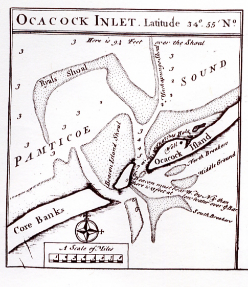
1733 Map of Ocracoke indicated a well and Thatche's Hole.
If we take this 1733 map at face value (pictured above), at first glance the ancient well appears to have been located somewhere near the present-day intersection of Tom Neal Drive and Oyster Creek Road-- this is if you look at the map and assume that the "bump" or widest part of the island is the modern-day Village of Ocracoke. This view is flawed because "Thatche's Hole" (today known as "Teach's Hole") is off the coast of modern day Springer's Point, which lies south of the Village of Ocracoke, not north as the 1733 map indicates. A different interpretation is that, after 1733, the coastal fluxuation and washover built up the island to the north of Springer's Point, creating the land for the Village of Ocracoke. If this is the case, the modern-day well at Springer's Point may be the same well indicated on the 1733 map.
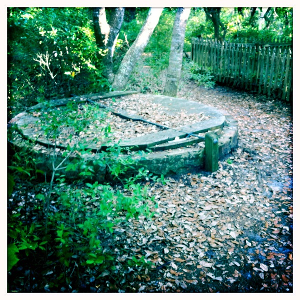
Well at Springer's Point
A bit of mystery surrounds this well. Locals suppose that the brick well was constructed in the 1800s, but maps and historic documents hint that perhaps the well is much older-- or this one was built in place of a much older well that was very close by.
Shortly before his death, Blackbeard held a legendary meeting-- what is considered to be the largest pirate gathering in North America. Attendees included Israel Hands, Charles Vane, Robert Deal, and John Rackham. For several days the pirates drank rum, barbecued hogs and cows on the beach, partied and relaxed (Lee 1974:89). This incredible festival occurred at Springer's Point, and might this area have been chosen for its fresh water well?
Is the well at Springer's Point the same well frequented by pirates in the 1700s? Who built the well? How long did the well exist before the bricks were (supposedly) laid in the 1800s? Did the well have a heavy significance to the Hatterask Native Americans, and were they the group who built the well to begin with? Though no evidence currently suggests, if this well is much older may it have attracted the colonists who abandoned Roanoke? An archeological excavation of this incredible landmark may yield interesting clues.
Today, this well is boarded up and featured on the Springer's Point nature walk. Centuries before, however, this well (or a nearby well no longer in existence) had a role in shaping the course of history. As an easy and secluded source of fresh water it became a secret meeting place for pirates and informed the nautical history of the fifteenth and sixteenth centuries.
Bibliography
Howard, Philip (et. al) 2010. "Ocracoke Cisterns" Ocracoke Newsletter. 11 October 2010.
Kelley, J.T (eds, et. al) 2009. "America's Most Vulnerable Coastal Communities." Geological Society of America Special Paper. 460-04, p. 43-72.
Lee, Robert E. 2002:1974. Blackbeard the Pirate: A Reappraisal of His Life and Times. Winston-Salem, North Carolina: John F. Blair Publishing.
Moseley, Edward. 1733. A New and Correct Map of the Province of North Carolina.
Riggs, Stanley R. (et. al) 2009. "Eye of a human hurricane: Pea Island, Oregon Inlet, and Bodie Island, northern Outer Banks, North Carolina." in Kelley, J.T (et. al).
Ocracoke Island Ocracoke Island Ocracoke Island Ocracoke Island Ocracoke Island Ocracoke Island Ocracoke Island Ocracoke Island OCracoke Island Ocracoke Island Ocracoke Island Ocracoke Island Ocracoke Island Ocracoke Island Portsmouth Island Portsmouth Island Portsmouth Island Portsmouth Island Blackbeard Blackbeard Blackbeard Blackbeard Blackbeard pirate pirate pirate pirate pirate

 RSS Feed